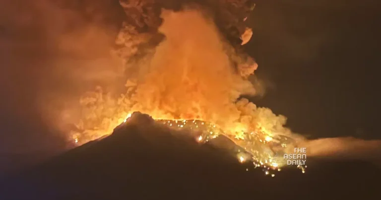
17-4-2024 (JAKARTA) The Center for Volcanology and Geological Hazard Mitigation (PVMBG) has reported an increase in the activity status of two mountains in North Sulawesi, namely Mount Ruang and Mount Awu. The heightened activity at Mount Ruang, located in Sitaro Regency, North Sulawesi Province, has led to its status being raised from level II (alert) to Level III (alert) as of April 16, 2024. Within a 12-hour period from 00:00 to 12:00 (Central Indonesia Time), there was an escalation in volcanic earthquakes with 198 recorded incidents, along with 2 instances of distant tectonic earthquakes.
At 01:08 on April 17, 2024, an eruption of Mount Ruang was recorded on the seismogram with a maximum amplitude of 55 mm and a duration of approximately 2 minutes. “Sounds of explosions and the rumble of the eruption are still ongoing as the report is being made,” said Hendra Gunawan, Head of PVMBG of the Geological Agency, in a statement on Wednesday (17/4/2024). Based on photos and videos sent by PVMBG, an explosive eruption of Mount Ruang occurred at 01:08, affecting 272 households or 838 individuals who are prepared for evacuation.
This is reportedly Mount Ruang tonight ???? ????
???? Marcellus Helmy Sitorus on FB pic.twitter.com/e9f60dlmrc
— Volcaholic ???? (@volcaholic1) April 16, 2024
As for Mount Awu in the Sangihe Islands Regency, North Sulawesi, its status has been raised from Level II (Alert) to Level III (Alert). According to Hendra, seismic activity at Mount Awu has been dominated by shallow volcanic earthquakes and deep volcanic earthquakes in the past two weeks. The breakdown of seismic activity includes 1 low-frequency earthquake, 284 shallow volcanic earthquakes, 71 deep volcanic earthquakes, 14 local tectonic earthquakes, and 252 distant tectonic earthquakes. Hendra advised the public not to enter or engage in activities within a 5 km radius from the center of Mount Awu’s crater. Additionally, they are urged to follow instructions from authorized agencies, namely the Geological Agency, which will continue to coordinate with the National Disaster Management Agency (BNPB), the Meteorology, Climatology, and Geophysics Agency (BMKG), relevant ministries, local governments, and other related institutions.


